Hiking the Cumbria Way: Ulverston to Carlisle through England's Lake District National Park
- Nicki Munro
- Dec 15, 2025
- 17 min read
Updated: Dec 16, 2025

There are few hiking experiences in the UK as captivating as walking the Cumbria Way. In fact, I would say this could be England’s answer to Scotland's internationally popular - West Highland Way. Stretching approximately 112 kilometres from the historic market town of Ulverston to the bustling city of Carlisle, this long-distance trail weaves through the heart of England’s stunning Lake District National Park. Whether you’re an experienced hiker or an enthusiastic beginner, the Cumbria Way rewards all who venture along its path with breathtaking views, quaint villages, and a sense of adventure that lingers well beyond the final mile.
Rating: 7.5/10
Trail companion: Solo hike
Planning your own trip? If you're just here for the logistics Click Here
Highlights of the Trail
The Cumbria Way offers a diverse array of landscapes, each with its own unique charm. The trail begins gently, winding through tranquil farmland and ancient woodlands as you leave Ulverston behind. Soon, the scenery transforms as you enter the Lake District proper, revealing dramatic fells, shimmering lakes, and lush valleys. Highlights for me include:
1. Walking along the tree-lined shores of Coniston Waters at the end of a long first day.
2. Crossing Stake Pass (albeit in the rain) and coming down the valley of Langstrath into Borrowdale, and arriving at the cozy Borrowdale Youth Hostel with a few campsite spaces. The lounge and bar was a nice place to warm up, try a local ale, and meet other hikers exploring the surrounding fells.
3. Exploring what could only be Mr McGregor's garden, at the old holiday residence of Beatrix Potter and learning about the establishment of the Lake District National Park.
4. Skiddaw House. The best lodging I’ve ever experienced for it’s uniqueness, remote location, and being the highest Youth Hostel in the UK. I was totally at peace here.
Getting Started: Preparation and Planning
Arriving in Ulverston after two connecting rides from Cardiff was a welcomed relief. I hadn’t done any homework on my starting point. Had I done - I would’ve booked an extra night at my Airbnb. Instantly charmed, I found an outdoor table at "The Farmers" pub, ordered a pint, and waited in the sun for my check-in time, watching the village life go by.
Ulverston can be dated back to 1086 with the first recording “Ulurestun” in the Domesday Book, under William the Conquerors' rule. Nearly 200 years later in 1280, the town was granted market charter by Kind Edward I, and the markets are still held today on a Thursday and Saturday. But the town isn’t just known for its market characteristics, the town prides itself as a festival town too. The proximity to both the waters of the Leven Estuary and having one of the most beautiful National Parks (the “Lakes”, of course), lends itself to hosting events for all to enjoy the environment, history, and hospitality of the region.
When I got to my accommodation, I sorted out my gear for the following day and tried to get an early night. This was my first hike out of Europe and New Zealand, and I assumed it would be easy navigation and pacing. The weather was my biggest concern, but I’d planned with rain in mind and as it turned out, rain became the main theme for the entire trip!
Ulverston to Coniston
Realising I had chosen a literal example of off-the-beaten-path for my first UK hike
Distance: 25km

This day was interesting for reasons I wasn’t expecting. Finding the starting point at “The Gill” was easy, as was about, well, the first five minutes. It wasn’t long until the path opened up into open fields, leaving me searching the horizon for anything resembling a trail marker, or trodden path.
In 2018 when I researched this walk, I found a couple of blogs recommending it, but there really wasn’t that much information to give me a fair idea of its popularity. In retrospect, the lack of information in itself, was a hint. In addition, I was starting this walk in the middle of autumn, when any decent traffic the track might have seen, would have long dwindled away.

So when I arrived in these big open spaces, I struggled to find summers’ well-trodden path to hint at the direction, when the blend-in-with-the-environment green & yellow markers didn’t stand out at a distance. I was familiar with the red and white flags of the GR’s in Europe, and New Zealand’s bright orange triangles, while having maps and compasses for the more remote options. But I wasn’t expecting to need that for this one. What I thankfully did have though, was a Cicerone Guide Book and a compass which saved me (I was literally reading and hiking for at least the first half of the day)!

The navigation got easier once in the Lake District proper, where the trails become more popular. And look, it’s probably much more popular now! GPS devices are more common use too, so use them if you’ve got them and you’ll fly through this day faster than I did.
The views back over Ulverston and out to the Leven Estuary enticed me to keep looking back, until it was the allure of the Coniston and Blawith Fells that drew me forward. I still had more “surely not” moments, walking through farmers paddocks, yards, and runs when my guide book spat out directions such as “On nearing Hollowmire farm a Cumbria Way sign guides the way on a short enclosed grass path leading to the farmhouse. Turn right through the farmyard and follow the farm lane out to the road, where you should turn left”. This is something so foreign to a kiwi girl, and I felt like I was trespassing or at least, heavily encroaching on people’s privacy. I became accustomed to it eventually, waving out to the farmers, and realised the opportunity to see the farm life in operation.
I passed through the town of Gawthwaite (here officially entering the Lake District National Park), ate a quick lunch, but realised my timing was much slower than expected due to this new navigation process. Thankfully, from here, directions and the official path became a lot clearer, and walking sped up.

Arriving at Beacon Tarn, I realised this was the beginning of water views, autumn hue tussocks, and mountain vistas. This was what I came for, and it encouraged me on for the last 10kms.
The final stage was the perfect ending after already trodding 20kms. The trees lining Coniston Water were just turning in shade, the sun was getting lower - glistening on the water, and the natural single-trail path, led me right to the paddock (just out of Coniston town) that would be my campsite for the night. I set up camp just as the sun was setting, checked out my surroundings, and ate a light dinner before settling in to my sleeping bag. Rest was much needed equally for my brain as it was for my legs and feet!
Coniston to Great Langdale
Breaking up the rain with devonshire tea and cozy pubs
Distance: 19km
The morning started without rain, and I made my porridge and cup of tea in the vestibule of my tent, before packing up and setting off.
Wanting to check out a bit of Coniston Village, I wandered into town for a coffee and to read my guide book about what the day ahead would bring. This was a picture perfect little village with stone buildings and bridges, water paths, big trees, all set under the Old Man of Coniston (part of the Furness Fells).

The trail started off heading past Coniston Hall (this is also where my campsite was), an impressive Grade II listed building from the 16th Century with four large chimneys. Then it was navigating through the streets, before the trails opened up into lush, open green fields. With an easy gradient, I was starting to head up into the fells again. Before I got to the woodland, I passed an old folly, where they used to keep hunting dogs.

The woodland section was the start of rain for the day and I pulled on my raincoat, and put an extra layer of protection over my bag. This section of the track was easy navigating and had beautiful views of the Yewdale Crags and waterfall. The rain would continue to be on-and-off for an hour, until it really set in for the rest of the day.
The woodland soon opened up into more gorse scattered fields that I’d had the day before. Coming from New Zealand, it was a relief to appreciate the gorse for its native beauty, than the usual scoff of frustration.

From soft paddocks to country roads, I got my first taste of the impact that came from long periods of hiking along the hard surfaces, giving my feet (in rigid hiking boots) an unwelcome wake-up. I followed a route (which was a road) called High Park Lane that lead me up past a pine plantation and down into High Park Farm. Apparently they do a B&B here, but I got lured in by the sign offering tea and scones. With the sun breaking through, and some relief for my sore feet, this was a real highlight of the trip that still lingers in my memory. The friendliness and authentic touch stood out, and yes – the scones were freshly baked and fluffy. The site of the house and it’s tea garden (where I refuelled outside) offered gorgeous surrounding views.
Skelwith Force waterfall was my next main attraction, and with the leaves slightly changing in colour for the season, it was pretty as a picture. It was also the first descent river I’d come across, and the energy had a positive impact on me. Everything on my path thus far, had been pretty and tranquil. I really noticed how the “force” of nature impacts your energy, and vice versa.
I don’t have much memory from the part between Skelwith Force and Chapel Stile. It started raining heavily, and I had press-on momentum. Elterwater was definitely picturesque, and I still saw more people on the trails than the first day despite the rain. But I couldn’t find a sheltered spot to eat something from my backpack, so when I got to Chapel Stile, I was easily tempted for some hot food, a pint, and a chance to look at possible accommodation options that were closer than my planned stay at Great Langdale. After replenishing my energy levels, I decided not to change my plans, stepped out of the warmth and bustling energy of the Inn, and back into the rain.
Arriving at Dungeon Ghyl, I turned left and went over the river to a campsite. They offered little pods which weren’t much more expensive than a campsite, but had nothing in it apart from a dry space to lay out my hiking mat. It saved me putting my tent up in the rain and, when you’re hiking, these little things make it feel like utter luxury.
Great Langdale to Borrowdale
Splitting the section in half to enjoy the fairytale charm of Borrowdale, and the adventure vibes of its YHA.
Distance: ~12km
Rain kicked off the day in beautiful British fashion again, and I was stoked to be packing up for the day in my dry pod!
Walking up the road to get back on track at the Dungeon Ghyll, I met another hiker who was also doing the Cumbria Way - my first encounter of another thru hiker! We chatted for a while before splitting up, and then I was caught behind a large school group heading up the valley alongside the Mickleden Beck. This section is a great path, easy walking, and a step back in time. Thankfully this allowed me to get past the excited group quickly, but I was impressed with their “whatever the weather” attitude.
The views of Pike O’ Stickle and Gimmer Crag come into view early. The National Trust records that here, evidence of Neolithic axe building activity took place in these mountains, and evidence of rejected axe heads have been found.

Reaching the base of Stake Pass, I looked up under my raincoat hood, and thought "Here we go!”. I was about to walk up the side of a cascading waterfall, and until now, I hadn’t had any real descent climbs. I took my pack off as the rain was easing, rested it against the large cairn, and took in my surroundings. Apart from looking back at the group of ants that was the school group, the entire place seemed a world away from anywhere.
I eventually started, one step in front of the other to take on the Pass. The sound of the water flowing from Stake Gill, and my quickened breath was all I could hear. Reaching the top, I had to step in the river to get through to the passes' Cairn (that was also a good size). Looking back, it wasn’t as difficult as I thought - I’d just had it pretty easy up until that time.
I shared the lonely, 360-degree view with a solo sheep. We didn’t need anyone else to take in the atmosphere - my appreciation of it all was only heightened.
As I left the saddle, I could soon see down the valley of Langstrath which appeared to go on forever. Stake Beck soon joined me and I found several opportunities (while it wasn’t raining), to take photos of the steep cascading falls. The rest of the journey down the valley was a balance of looking up to the views of the mountains and crags that I was passing beneath and looking out to, and watching my step with a mix of long grasses and boulders sticking up, and out from the path I was taking.


A short while after passing through Rosthwaite, I walked through a field of campers whom I was very tempted to join as the rain was definitely at my heels. I pushed on however, and was glad I did, when I arrived in a gorgeous little village - Borrowdale (if it was even that size). I passed an impressive hotel that I resisted enquiring at, but not long after, I saw signs to a YHA. When it appeared, I noticed a couple of tents pitched already on the grounds surrounding it. I dumped my pack on the ground and a familiar face popped their head out from their tent… It was the guy I’d met starting off in the rain at the beginning of the day! We had similar ideas of getting the tent up while it wasn’t raining and drying out wet-weather gear in the dry room.

I walked inside the hostel, and enquired about both the room and tent options. They were both available, but something in the back of my head said to save the indoor stays for when I really needed it.

It looked like this Hostel was used by a lot of adventurer's. At this point in Borrowdale, people were using it for the Cumbria Way, the Wainwrights Coast-to-Coast walk, and just as a base for all the offshoots of trails in the surrounding area. I remember this place fondly for the great hospitality, it’s location, and it’s humming little lounge bar where I met other travellers and quizzed them on possible next trails. The Wainwrights Coast-to-Coast definitely got me excited, and it still sits in the back of my mind as a box that needs to checked.
Borrowdale to Keswick
Beatrix Potter territory, Derwent Water, and the market town of Keswick
Distance: ~12km
It felt like this day went quickly, even though it was around equal distance to the day before. There wasn’t a significant climb, and the trail passing Derwent Water was relatively flat.
It must have been the weekend because I was suddenly passed by a very fast runner. He had a numbered bib on, and quite a while after him, more runners came. To this day I am still unsure what the race name was, but I think it actually might have followed the entire Cumbria Way!
The following sections, although still pleasant, were definitely some of the least memorable for me. A mix of woodland and lake views, and the occasional sighting of mountains in the distance (the weather wasn’t offering me too much, apart from a day free of rain) made it pleasant enough though.
I stopped at Hawes End for a coffee and bite to eat. It was very busy – full car park and café, and a real hive of activity with an Outdoor Education Centre. When I got back on the track, even more runners were coming through.
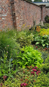
With not too much further to go until Keswick (and making good time), I approached Beatrix Potter territory, and took the time to explore. Lingholm is a beautiful home where Beatrix apparently spent a lot of time during summer holidays, sketching and writing. The gardens were especially interesting to me being a keen vegetable gardener. This one really showed me up though, and I wondered if it came before or after the inspiration for Benjamin Bunny and Mr McGregor's garden. Either way, my childhood nostalgia was certainly ignited!


Arriving in Keswick felt like a city after the past four days, but I think the weekend's events added to that. Keswick can be dated back to AD 553 by St Kentigern in Great Crosthwaite where it is thought he built a church under which the current version stands today (still dedicated to St Kentigern).
I found a campsite in a campground near the lake, set up my abode, and wandered into town to take in the lively atmosphere. I didn’t find out what the commotion was about, but I enjoyed the festive scene (whatever it was for), somehow snagged a table outside a busy pub, and treated myself to the traditional pub fare.
Keswick to Skiddaw House
Leaving the Lake District NP, and finding my favourite place to stay on the Cumbria Way
Distance: 8km
My night in the tent started with clear skies, then rain, then a shaded tent site as I packed down my wet tent. Knowing I didn’t have a long walk today, I figured I’d just get to Skiddaw House and set up camp early to let it dry out.
After refilling my stocks in Keswick, I found my way out of the village and back on to the trail. It was steep climbing to start, with the alluring Skiddaw fells ahead of me. The sun was shining, and it was beautiful day. As the climb opened up to Skiddaw carpark, I realised that the race event markers were up, and there were still people going through. I stopped and talked to one of the marshals who said they’d had a busy night with a handful of people going off trail and losing their way back. I found out it was an ultramarathon, and people were covering the entire Cumbria Way distance in one go.
The walk from here followed a path that lead me into a narrow, and deep valley. The landscape was magnificent and I passed a couple of friendly hikers heading the opposite way. Other than them, and a few sheep – the trail, again, was surprisingly quiet.
A continued easy walk allowed me to arrive at Skiddaw House hostel (the highest UK hostel), nice and early, with not a single soul in sight. I took a look around the inside and decided this place was too much of a novelty not to experience (besides, the camping area outside was a little overgrown). I hung my tent out to dry on a washing line out back, and made a cup of tea in the kitchen.

The hostel stocked a few meal options, and beer from a local brewery in a near town (which I would be passing through the next day). I decided to make my own meal, but a pre-dinner beer in front of the fire was not going to be resisted.
Only two other people arrived to stay that night. I felt so lucky to experience this place and almost get to pretend like it was my own slice of paradise. The lounge was also filled with books. I hadn’t been able to carry my own (apart from my guide) so I spent the evening in front of the fire with a cup of tea, and book(s) in hand.
Skiddaw House to Caldbeck
Distance: 20.5km

I don’t mean to keep talking about the weather, but I had hoped on this day I could take the high route onwards. The clagged in rain and clouds did not permit and I continued on the foul-weather route. Looking back at my refuge for the past night, I noticed how creepy it looked with the larch trees, deformed in their position from the winds. My night there was more than comfortable though, and most certainly the most memorable.
The bridge in the picture to the right is an interesting feature. As the guidebook states, this seems like an insignificant moment. But this is the beginning of the river (at this stage not looking like more than a creek) that I would be following most of the following day, into Carlisle.
This track, in my opinion, doesn’t have too much worth mentioning. I was back to following faint trails across large fields, pounding long sealed roads, and in all honesty – I just wanted to arrive in Caldbeck as quickly as possible.
And Caldbeck was a delight! This town dates back to the 6th Century (again, tied to a church built by St Kentigern). I stayed at the Oddfellows Arms (great hospitality, great restaurant), and spent the afternoon exploring the boutique shops.
Caldbeck to Carlisle
The final leg!
Distance: 25kms

I really loved the first half of this day. It rained steadily through the morning, but that didn’t matter – the path was easy to follow, mostly flat, and I think I just had that final stretch mentality. As mentioned earlier, most of the morning was following the River Caldew – and it was a funny feeling to be reacquainted with the water source from yesterday. Woodlands, river views, and open fields dominated this section, until a couple of historic features took my interest. The Rose Bridge, and Rose Castle.
The Rose Bridge was one of three historic bridges I came across (there was also the Sebergham Bridge (1689) and the Bell Bridge (1772, but it got washed away after Storm Desmond in 2016 .... now replaced by another £1.1m bridge). I am not sure when the Rose Bridge was built but it is near Rose Castle which stands out immediately on approach.

Rose Castle has quite a history (and unfortunately I didn't stop to take photos), with the castle first being built in 1230 for Bishop Walter Mauclerc who was gifted the land by Henry II. The castle has gone through centuries of warfare and fires, re-establishing each time to what it is today.
The second half of the day was the least pleasant of the whole trip. I had read somewhere that the Cumbria Way should end in Dalston (and there’s possibly even an argument for it finishing back in Caldbeck too). Walking into Dalston my feet were already aching from the tar sealed path, and this was just the beginning. I was entering the industrial and commercial outskirts of Carlisle, passing factories, railway lines, and frequently increasing traffic. I guess that’s what you get if you’re planning to walk all the way to the Carlisle Cathedral where the official trail ends. The actual inner city itself was far more pleasant, and I dropped my bag off at my accomodation (ahead of check in), and continued up to the Cathedral.
Had my feet not been in the tortured state they were from the hard surface to surface impact, I would of (and now regret) not spending at least a couple of hours exploring the inner walls and the history behind it all. I returned to my accommodation, found there was hot chocolate and cookies in my room, and put my feet up for the afternoon before heading out for dinner.
Looking back, I would have scheduled at least another full day to explore this beautiful city and the Cathedral. But the next day, I was booked on a train for Glasgow to commence … the West Highland Way (Blog coming 2026).
Final Thoughts
Hiking the Cumbria Way is more than just a walk; it’s a journey through some of England’s most captivating landscapes, rich history, and warm hospitality. Whether you’re someone seeking solitude among the fells or camaraderie in a country pub, this trail delivers an experience that’s both challenging and deeply rewarding. The beauty of the Lake District has something for everyone and I think the Cumbria Way offers a way to experience it all.
Practical tips for hikers
Weather in the Lake District can be unpredictable—pack waterproofs and layers, no matter the season. I had rain at least once a day.
A soft - medium hiking boot or trail runner should get you through. I made the mistake of wearing rigid hiking boots made for varying rough and wet terrain (Mendell - Island Lady), but paid for it on the often sealed paths. A hard boot is not necessary, or recommended.
Carry plenty of water and/or water purification.
Consider splitting up longer stages if you’re looking for a more relaxed pace—there’s no need to rush and the accommodation options and villages are worth spending the extra time in for exploring.
Guide Book
Walking the Cumbria Way - Cicerone
Accommodation I used
Ulverston: Airbnb
Coniston: Coniston Hall Campground
https://conistonhallcampsite.co.uk/
Great Langdale: Great Landale Campsite https://www.nationaltrust.org.uk/holidays/lake-district/great-langdale-campsite
Borrowdale YHA: Campsite and rooms
https://www.yha.org.uk/hostel/yha-borrowdale
Keswick: Keswick Camping and Caravanning Club Site
Skiddaw House: Camping and rooms
https://www.skiddawhouse.co.uk/
Caldbeck: Oddfellows Arms - rooms
https://www.oddfellows-caldbeck.co.uk/
Carlisle: Cornerways Guesthouse
Note:
There are both low and high routes to the Cumbria Way. This account mostly follows the official / main low route because of the weather.

Comments